
On the Road Again
Summer has arrived and school is out. It’s time for summer vacation! Today traveling is easy to do: just grab a map or GPS or, if you’re adventurous, hop on the road and go. Along the way you will probably see signs that point you to your destination or you might listen to your GPS as it directs you. But if you didn’t have these tools, what would you do? How would you know if you were on the right track? One possible answer: topographical maps.
Topographical maps are overhead maps that feature geological and man-made features. They continue to be used for travel – hiking through woods, for example – or development, such as erecting buildings or dwellings. These same uses were practical, even necessary, when Thomas Hutchins published his Topographical Description of Virginia, Pennsylvania, Maryland and North Carolina in 1787. In it he depicts mountains, creeks, rivers, and so on, as well as describing the flora and fauna of the regions he surveyed.
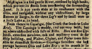
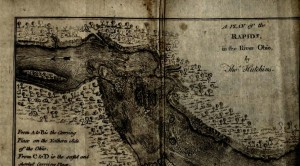
The book’s catalog record in WorldCat indicates that it includes three maps; unfortunately, one map has been removed from our copy. Remaining maps include a plan of villages along the Mississippi and a plan of the rapids in the Ohio River, seen above. It also describes the Muskingum River – a “fine, gentle river, confined by high banks, which prevent its floods from overflowing the surrounding land” – and the Cuyahoga, which was muddy and not very swift.
We’re fortunate in that we generally have access to online versions of publications such as this, making it easy to use them as tools for travel. Sure, maps of this age are outdated, but how fun would it be to use one on summer vacation this year? Just as we often compare old pictures of buildings with Google street shots, we can use old topographical maps or other maps like them to see just how things have changed. Why not give it a try? Compare our landscape of today with that of yesterday. Find out what you might have seen if you, like Thomas Hutchins, had been a traveler in the 18th century. And then let us know what you discover!
_______________________________________________________________________________
Thank you to Shannon Kupfer, Digital/Tangible Media Cataloger at the State Library of Ohio, for this week’s post!


Leave a Reply
You must be logged in to post a comment.